


Past and present geomorphological hazard and cultural heritage loss in El Castellar castle scarp (central Ebro basin, Spain).
Peña-Monné, J.L., Sampietro-Vattuone, M.M., Espinalt Brillas, M., Gutiérrez-González, F.J., 2023. Past and present geomorphological hazard and cultural heritage loss in El Castellar castle scarp (central Ebro basin, Spain). Geographical Research Letters, 49 |
RESUMEN.
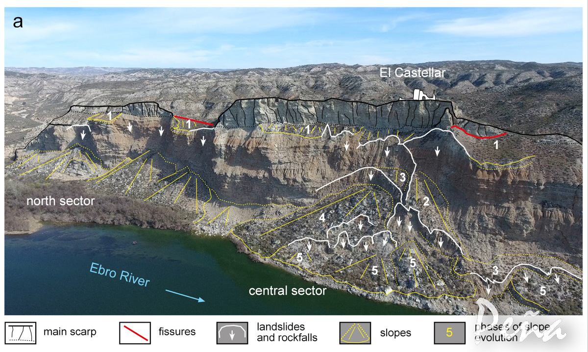
Las ruinas del castillo medieval y villa de El Castellar se sitúan sobre un abrupto escarpe de yesos del Mioceno de 1,2 km de longitud, en el sector central de la Depresión del Ebro. Los restos medievales del castillo principal de El Castellar se alzan sobre un acantilado de 100 m sobre el río Ebro. Teniendo en cuenta la relevancia histórica y geoarqueológica del poblamiento de El Castellar, esta investigación tiene como objetivo estudiar los peligros geomorfológicos y el contexto paleoambiental del yacimiento durante y después del poblamiento y su evolución posterior, incluyendo su estado actual. Para lograr este objetivo se determinó el contexto geomorfológico analizando la dinámica de cada sector del escarpe. Los datos geomorfológicos sugieren que en época medieval sus construcciones se vieron favorecidas por las condiciones ambientales de la Anomalía Climática Medieval (ACM). En esa época, el río Ebro estaba situado en una posición centrada en su llanura de inundación, y los abanicos aluviales laterales protegían el escarpe de la erosión basal. Posteriormente, durante la Pequeña Edad del Hielo (LIA), grandes caudales y recurrentes inundaciones cambiaron la dinámica del río y promovieron el movimiento del cauce contra el escarpe, desestabilizando su pie y generando grandes derrumbes y desprendimientos, favoreciendo así su retroceso. Los edificios del pueblo y el castillo en la parte superior de la escarpa sufrieron graves daños. Por varias razones, la zona no es de fácil acceso, pero aún contiene un importante patrimonio arqueológico que merece ser estudiado y preservado.
ABSTRACT.
The ruins of the Medieval castle and village of El Castellar are located on an abrupt 1.2-km-long scarp of Miocene gypsums, in the central sector of the Ebro depression. The Medieval remains of the main El Castellar castle are perched on a 100 m cliff on the Ebro River. Considering the historical and geoarchaeological relevance of El Castellar settlement, this investigation aimed to study the geomorphological hazards and paleoenvironmental context of the site during and after the settlement and its later evolution, including its current state. To afford this objective the geomorphological context was determined analyzing the dynamics of each scarp sector. Geomorphological data suggest that in Medieval times its constructions were favored by the Medieval Climatic Anomaly (MCA) environmental conditions. During that times, the Ebro River was located in a centered position on its floodplain, and lateral alluvial fans protected the scarp from basal erosion. Later, during the Little Ice Age (LIA), great climatic flows and recurrent floods changed the river dynamics and promoted the river channel movement against the scarp, destabilizing its foot and generating large landslides and rockfalls, thus promoting its retreat. The village buildings and castle at the top of the scarp were seriously damaged. For several reasons, the area is not easily accessible, but it still contains a relevant archaeological heritage that deserves to be studied and preserved.